This is a journal of my adventures. The title is from a story by the Greek historian Herodotus. In 600 BC the Pharaoh Necho II sent a fleet of ships to discover if Africa was entirely surrounded by water. It is probably the earliest recorded mention of a simple geographical phenomenon - that in the southern hemisphere the sun lies to the north. To me this phrase signifies the excitement and challenges of the adventures that I actively seek out.
Sunday, June 26, 2016
Hike to the Tahquitz Peak Fire Lookout
Tahquitz Peak Lookout at its elevation of 8,846 feet is the highest lookout in the San Bernardino National Forest. It is also the forest’s longest continuously operated station, serving some 77 years, and is the only lookout located inside a Wilderness area. This is a zoom lens shot of the lookout nestled on the high peak.
The terrain is very similar to the Sierras and the Devils Slide trail is well groomed and never really steep. The first leg of the hike is 2.5 miles to Saddle Junction. This is Alan on the last stretch of trail before the fire lookout.
Recent fires have closed a number of areas and trails.
The trails are well marked and many feature new signs. All that is needed to navigate is the day hike permit and the free USFS paper map that outlines the trails.
The vegetation at lower altitudes is composed of a variety of trees and manzanita bushes but as you ascend the manzanita bushes grow smaller and the pine trees form a dense canopy, providing shade and welcome relief from the sun in summer months.
Many large boulders provide a look similar to the high Sierra mountains.
From Saddle Junction to Tahquitz Peak is another 1.9 miles and the lookout provides enormous vistas that reward hiker's efforts to trek there.
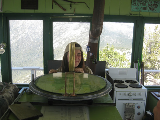
Volunteers staff the lookout and Carol gave a tour of the lookout's interior as well as demonstrated the device used for locating fires and lightning strikes.
The sighting devices were created by William "W.B." Osborne, a USFS employee and have been in service since 1915. The system is composed of a topo map of the area on a horizontal table with a circular rim graduated in degrees. Two sighting apertures are mounted above the map on opposite sides of the ring and slide around the arc.
Carol taking a sighting.
Carol explaining how the topo map and scales are used to estimate distances.
The device is used by moving the sights until the observer can peek through the nearer sighting hole and view the cross hairs in the further sight aligned with the fire. The fire lookout notes the degrees on the graduated ring beneath the sight. Early Fire Finders were capable of a crude estimate of elevation based upon the level and elevation of the table, calculating distance and rough position of the fire by reference to any distinctive terrain features and by use of the scale shown on the map. However, in actual practice, fire distance and location were normally established using two or more Fire Finder-equipped towers, using the intersection method to fix the precise location of the fire.Dispatchers at a central facility used a compass rose to mark lines of position from each reporting tower onto a large map to quickly find where the reported bearings intersect.
Overall Alan and I hiked almost 11 miles and ascended 2600' when exploring the trails. The temperatures were nice at altitude especially when strong breezes stirred the air.
Subscribe to:
Post Comments (Atom)


What a great destination for a day hike! The Osborne Firefinder is a cool piece of USFS history. Thanks for the post!
ReplyDelete