

For the weekend of May 4-5-6, I led a large group of overlanding friends to explore an area in the Inyo Mountains known as Papoose Flats. This area also included Mazourka Canyon, Mazourka Peak, Squaw Flats, Harkless Flats and the Narrows. This section of the Inyo National Forest is located a little east of Big Pine, California.


The convoy heading out early Friday morning

We had quite a diverse group of vehicles including a stock vehicles, a 60's Land Rover, Land Cruisers and more that come together to explore and camp. This is a shot of the initial group high atop Mazourka Peak where numerous radio relay sites keep a silent watch high above Highway 395.

Even more interesting than the vehicles were all of my friends who owned them!

We chose the more difficult route into Papoose Flats by coming in from the south through Mazourka Canyon. This route includes rocky terrain, tight turns, numerous trees as well as a bit of routefinding. The northern routes from the old Death Valley Road are much much easier but are still unimproved roads with steep hills and loose dirt. This picture is where we aired down our tires in Mazourka Canyon. Dropping the air pressure increases the contact area, or "patch" of the tire tread to the ground. It also helps the tire to conform to rocks and irregular terrain.

Papoose Flats offers quite a varied expanse of terrain with very scenic views of the Sierra Nevada Mountains as well as steep roads, narrow canyons and interesting mines.


Friday night's campfire being enjoyed by Jason, Chris and Dave

We also had some wonderful entertainment; Live bluegrass music!

My trailer's Roof Top Tent (RTT) under clear and starry skies and lit externally by the bright moonlight.

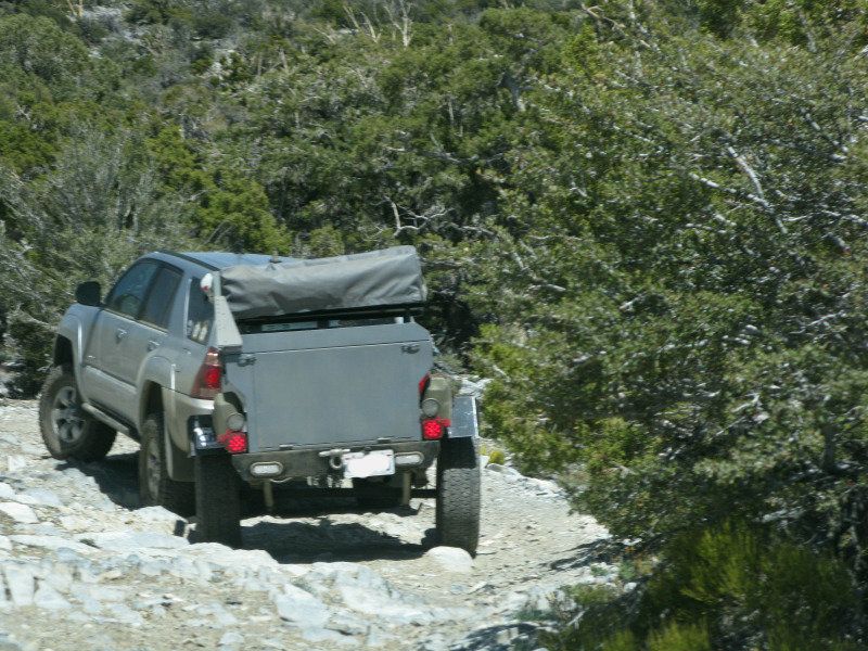
The trailer tracked really well through rough terrain
On Saturday a smaller group of vehicles headed out to the Narrows. Other folks stayed in camp to hike, nap or take shorter drives. The next two pictures are from the very steep northward route to go to the Narrows. I would not recommend it for inexperienced drivers! Also be sure to have tire repair equipment and recovery gear while out in this area.


Heading down into the Narrows from the north. That is Ian's well equipped Land Cruiser ahead of me.

Inspecting an old mining cabin in the Narrows

Joey & Jason are viewing a classic old refrigerator damaged by thoughtless people.

The fabled Mines of Moria?


The furry flying new owner of the Narrows mine!!


The furry flying new owner of the Narrows mine!!

During our exit of the Narrows we had one vehicle suffer a flat tire after all of the other vehicles passed through the same point. It is typical of the unexpected things that demand that you be well prepared. With a good spare and the right tools we were quickly on our way.
After making it back to Death Valley Road we dropped into Harkless Flats to test out the crossover route that connects to the main road into Papoose Flats. It did have some steep and loose sections but it was actually a better road than the main northern route into Papoose Flats.
Saturday night was Cinco de Mayo and Dave and Jody prepared some wonderful tacos that they shared with all. After another great campfire everyone turned in for the night. Outside of our tents the "super" moon cast a bright light on our nomadic campground as we all slumbered through the freezing temperatures.

On the final day of our adventure some folks continued the exploration by heading back over to Harkless Flats to check out the terrain and some more old mines. All the way out we were very ably guided by Chris' young son who was quite adept at using a topographic mapping app on an iPad.

Here we are starting from a fairly high altitude above the Owens Valley, heading down a descent of almost 500 feet to the old JM mine. The trail is a really well built path that could easily handle pack mules.

Joey is really enjoying the views! I can't wait to see all of his photos!

The long hot hike was rewarded with an amazing mine clinging precariously to the side of the mountain! Remember that many mines are very dangerous so it is best to just take pictures.

A skilled team of mining veterans demonstrates how to haul ore in a uniquely modified wheelbarrow.

After making it back to Death Valley Road we dropped into Harkless Flats to test out the crossover route that connects to the main road into Papoose Flats. It did have some steep and loose sections but it was actually a better road than the main northern route into Papoose Flats.
Saturday night was Cinco de Mayo and Dave and Jody prepared some wonderful tacos that they shared with all. After another great campfire everyone turned in for the night. Outside of our tents the "super" moon cast a bright light on our nomadic campground as we all slumbered through the freezing temperatures.

On the final day of our adventure some folks continued the exploration by heading back over to Harkless Flats to check out the terrain and some more old mines. All the way out we were very ably guided by Chris' young son who was quite adept at using a topographic mapping app on an iPad.

Here we are starting from a fairly high altitude above the Owens Valley, heading down a descent of almost 500 feet to the old JM mine. The trail is a really well built path that could easily handle pack mules.

Joey is really enjoying the views! I can't wait to see all of his photos!

The long hot hike was rewarded with an amazing mine clinging precariously to the side of the mountain! Remember that many mines are very dangerous so it is best to just take pictures.

A skilled team of mining veterans demonstrates how to haul ore in a uniquely modified wheelbarrow.

Trudging back up the steep incline.

After a brief stop at another abandoned mine we headed back to pavement to air up again. After what seemed like endless days of exploring I was sad that the adventure was ending.


After a brief stop at another abandoned mine we headed back to pavement to air up again. After what seemed like endless days of exploring I was sad that the adventure was ending.

To commemorate the good times and memories we had an official Expedition sticker created for everyone's vehicles. For those of you who could not make this trip I am glad that you were able to stop by and share the adventure here at Sun To The North!


