Featured Post

My Expedition Vehicle & Trailer

Friday, November 16, 2012

Exploring the Mojave Desert: In Search Of History

The cooler temperatures of November make daytime exploration of desert terrain much more pleasant although nighttime can be uncomfortably cold.  These unlit signs on the Park's borders are easy to miss at night but when properly used a modern GPS can keep you on track.

I recently set out to explore Warm Spring Canyon as well as some other nearby sites that interested me. The Canyon runs East-West between The West Side Road and Striped Butte Valley in Death Valley National Park.

Before heading into the Canyon I stopped by the Ashford Mill Ruins for a few photos. I liked the rough texture and cake-like layers of the poured concrete walls. The empty doorways make for nice picture frames too!

In the future I want to hike up to the Ashford Mine site, about 2 miles and a thousand feet of elevation gain. It is located about five miles east of the Mill ruins at the end of a 3 mile rough dirt road.

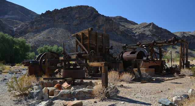
A ways up Warm Spring Canyon is a site with a fine collection of old ore processing machinery including a mechanically powered arrastra and other ore crushing and separating machinery.

The wild burros love to jump into camera shots! If there is a source of water near you then keep an eye out for them hanging around. The burros are high upon the National Park's hate list and they orchestrate roundups and sales of the crafty critters. Too bad for these obstinate survivors whose ancestors were abandoned by mankind.

Larry, Moe and Curly; Felonious scofflaws giving me their patented "Triple Evil Eye Stare-Down". How could I ever hold out against such malevolence! Best to keep driving along.

This mechanically powered arrastra reminds me of Oz's Tinman, slowly rusting as they patiently wait to be set in motion once again.

Next on my list was Striped Butte Valley where you can find expansive views and the still habitable living quarters of former Death Valley denizens. Many of these cabins are located by year-round springs. Note that if you should choose to travel through Goler Wash and Mengel Pass you need to have a capable rig and the ability to properly drive it.

Geologist's Cabin (or Stone Cabin)

Please pay the nice man the special entrance fee to see Stella's Cabin.....

"Stella's" Cabin, built around 1935.

The absolutely best views of Striped Butte are from a little hill next to Russel's Camp. This cabin is a ramshackle but quite functional collection of timber and corrugated steel that has been cobbled onto the original living quarters.

Volunteers have donated countless hours and materials to keeping this site in useable shape and that includes the shiny new outhouse with the welded steel frame.

Your reserved seat for spectacular views awaits you....

SoCal AAA maps describe the near vertical sediments of the Butte as having been shaped by "prodigious geologic forces".

A windshield view of the eastward drive back across the 7 miles of  Striped Butte Valley and then up into Warm Spring Canyon.

While I was poking around some old mining ruins in the Canyon a group of about ten offroad motorcycles was heading West to East, oblivious to my surreptitious photography.


On my last day I explored what I feel are some of the more spectacular mine ruins that are out there. They have suffered from some vandalism and littering so please treat them with respect. I will leave it up to you to find their true location so you must be responsible for your own choices and actions.

I really liked the warm colors of the red rust and old green paint that contrasted with the rocky hillsides and cool blue desert sky.


Just imagine what this ore cart trestle looked like when miners with gold fever were hurriedly dumping excavated dirt as fast as they could. The trestle used to span the canyon but has collapsed into a jumble of timber.

Inside the mine there are amazing sights of head frames, ladders descending into the depths, ore chutes, ore cart tracks and extensive excavations with well-fitted lumber bracing.


Think that you are ready to climb down this ladder? You had better not do it!

Old mines are dangerous! Every time some caution-challenged individual dies the federal Government closes down or obliterates priceless mining history. Just look at pictures of the Keane Wonder Mine in Death Valley for a recent closure of a fantastic site.

I am always captivated by the sight of ore cart tracks snaking into the gloom towards more fantastic discoveries.


My truck provides a sense of scale for this mighty ore collection bin.


The only gas station in Shoshone! 
I laughed it off since I had ten gallons of extra gas up on my roof rack.

If you know where to look you can sometimes spot the U.S. Marines out and about in their off-road vehicles.


This area is so huge and so packed with great history that I know that I will be heading back soon. Until then, have some great adventures of your own and thank you for visiting my blog!

Monday, November 5, 2012

Fremont-Kramer Desert Wildlife Management Area 2012 Camping

In October, 2012 a friend of mine invited me to join him for a camping trip to a stretch of desert not far from the Randsburg mining district. This area is north east of the junction of highways 395 and 58, roughly west of Barstow, California. Many folks think that the Mojave is simply empty land but it is home to a wide range of wildlife: the Mohave Ground Squirrel, California Jackrabbit, rattlesnakes, desert tortises, bats that roost in abandoned mines and the smallest owl in North America, the 10 inch high burrowing owl. Although the Mojave desert vegetation is mostly shrubs such as saltbush and creosote, the Mojave Fish-hook Cactus (Sclerocactus polyancistrus) is a rare but interesting sight with vividly hued flowers. The tiny Barstow Wooly Sunflower (Eriophyllum mohavense) grows nowhere else except here but only lasts 3 weeks if they have the right amount of winter rains. Speaking of rain, the creosote bush can survive up to two years without rain and give off a distinctive smell that I associate with great camping trips.


On this trip we kept our campsite in one spot and set up various antennas to experiment with radio communications and also to eavesdrop on the aircraft that ply the R-2508 flight area for Edwards Air Force Base and China Lake Naval Air Weapons Station. http://www.edwards.af.mil/shared/media/document/AFD-070103-052.pdf

We had some great views from our camp site!

Mike showed up in his new "work" clothes and set up the comms gear along with the antenna mast and foldable solar panels.


At one point we were treated to a graceful flyover of the all-black B-2 stealth bomber as it headed into a landing at Edwards AFB.

On Saturday Mike and I went on a short hike to the top of Fremont Peak, about 900 feet of  rugged elevation gain. We followed an old mining road part way up and then hiked up through the rocks to the right of the peak.


At the top I was able to access a VHF mountain top repeater that was 102 miles away! The handheld I am using is a 5 Watt Datron Guardian.
Photo by Mike

Mike hiked up with and operated an extremely compact HF radio station that fits in a small Pelican case and drives a simple end fed long wire antenna.

Sal kept an eye on the comms gear and worked on firearms proficiency while Mike and I were hiking.

This area is riddled with numerous mine adits and extremely deep vertical shafts.

There are a variety of artifacts laying about such as this short but burly iron spike.

Before too long it was time to pack up and get ready to roll out across the desert roads.

On the drive out we saw a sign that might explain a lot of racket that we heard late at night. The noise was a cross between an out of control stamp mill and a large group of crazed monkeys on drums and bongos.

Maybe it was some sort of Christian clandestine spiritual meeting that night? From the top of Fremont Peak Mike and I had scanned the area with binoculars and could not spot any encampments near by us. Maybe it was the ghostly echo of the old stamp mills that used to occupy the site...?

Thanks for coming out to the beautiful Mojave desert with me again! I hope that you have enjoyed the story and the pictures!

Monday, October 8, 2012

Exploring Blewett Pass

In June of 2012 I had an opportunity to explore areas that were a little further east of my previous trips. The state of Washington has a very interesting history with regards to gold mining but I found that the wet climate is very destructive of wooden structures. What is readily preserved in Southern California's dry desert climate is not something that may last long with the yearly 9 months of rain and snow that descends upon western Washington.

It was 1858 when Mortimer Robinson found gold in the gravel of Peshastin Creek. By 1874 the placer workings had run out but veins of gold had been discovered and soon the hills were riddled with thousands of feet of tunnels and vertical shafts. The small town that was established was originally called Warner when the US Post office was established but later in 1893 it was changed to Blewett after Edward Blewett of Seattle. His gold mining company controlled the majority of the claims in the hills around the creek. The current highway runs right through the original town site at an elevation of 2,328 feet. The town once included a two story hotel, school, telegraph office, boarding house, log cabin and frame homes as well as the inevitable saloon.


This building may have been the one covering the stamp mill remains in the next pictures below

This once mighty twenty stamp mill is now a frail shadow that is mainly composed of rotten wood and rusty hardware. It is located just off the highway near the forestry road's gated entrance.

This fascinating 30 foot diameter wooden water wheel is gone but possibly it powered the early arrastre for grinding ore.

Some of the modern miners are lacking in stewardship of the land in their rush to mine for gold. The ore cart track system is likely to be old stock "salvaged" from other mining claims. There were literally piles of rusty track all up and down the road.

Many old mines have been extensively renovated in the quest for highly valuable gold. This picture was taken without entering the mine.

Yet some facilities still lie dormant, such as these ore cart tracks covered in a carpet of pine needles. They lead to a chute that brought ore to a mill.

Here the road passes through the middle of one operation. The extensive tunnels' entrance is covered in a landslide yet someone is keeping the buildings in good shape.

This old air powered Eimco 12B rocker shovel has a new paint job despite sitting unused for many years. It was attached to a dump cart and an Eimco 401 compressed air powered locomotive.

This site was well back from the road but looked to be well maintained with buildings sporting stout doors and windows.

Keep out!

I found this sign above a 300 foot deep vertical shaft

The full story of Ronald's demise is here on page 4 http://www.dnr.wa.gov/Publications/ger_dgernews_2006_v3_no3.pdf
"Photos found on the camera of Ronald Calder, 46, suggest he'd explored caves and mines in the area before attempting to descend into an abandoned gold mine, said Detective Mitch Matheson of the Chelan County's Sheriff's Office. Calder set out June 20. His car was found at a monument on the Old Blewett Highway about 8 miles north of the summit and 1.5 miles from the mine shaft. Calder appears to have tied a rope around a tree and descended about 100 feet into the shaft, which was about 4 feet by 4 feet wide, Matheson said. The detective believes that Calder then unhitched himself on a ledge to explore some horizontal shafts in the mine and was later unable to grab back onto his rope. Matheson said the temperature was about 55 degrees in the shaft and that Calder, an inexperienced climber, was wearing only light clothing, having left his pack at the top. A coroner's report indicates Calder died of hypothermia, Matheson said."

 It was a remote and lonely place to die alone.

When researching where to go I found some fascinating photos and narrative about Blewett Pass at this site:
http://www.brian894x4.com/Washeastcascadestripday3.html   It is interesting to compare his 2003 photos with mine and note some interesting changes.

The holders of the current mining claims have posted all sorts of dire warnings in an attempt to curtail legal access to the public forestry road. The road crosses right through some mining claims so it is difficult to respect the rights of the owners in those situations. Take pictures and nothing else!

Old gas and diesel engines from Hercules and Cleveland tractor (Cletrac) litter the hillsides.

When searching for the old tramline that ascended 1000 feet up the hills I came across a segment of early 1900s wire rope. It consists of a hemp rope center wrapped by 6 large cables each of which is made of 19 smaller strands. These were very common with logging operations that pulled logs through systems of chutes.

I could not find any standing towers. This picture of a collapsed one that looked to be a double A-Frame is the best that I could do.

This grainy telephoto shot shows the roller located at the top of the tower for the drive cable.

When I made it up the full 1,000 feet to the top of the forestry road I was greeted with wonderous vistas of the craggy Cascades as well as Spring wildflowers.

Be sure to explore the surrounding area for great photo opportunities such as this Northwest Engineering pull shovel!

Or this really blue Studebaker truck.

Thanks for visiting my blog and sharing the adventure. Be sure to share the blog with your friends and family!